Mediæval Wales
"Mediæval Wales arose out of
the confusion caused by the withdrawal of the occupying Roman legions from
the British Isles in the early fifth century and the resultant raids and
settlement of the invading Germanic tribes from the Continent. The
original Celtic inhabitants of Britain were now scattered to the more remote
areas, where they retained much of their ancient culture. Regarded
as 'foreigners' by the Anglo-Saxon settlers, one such isolated group of
Celts became the Welsh."
-Norman F. Cantor (ed.) The Encyclopædia
of the Middle Ages, New York, 1999
It has been suggested that
the Sewell name might be derived from the Anglo-Saxon "Se-Wealh" which
means "the foreigner"; i.e., not of Saxon origin, but Celtic or Romano-Briton.
However, it is more likely that he name originates with "Sewald" or "Cedwalla",
an appelation in Saxon times.
-condensed from a letter written by {Rev}
Henry Doyle Sewell, February 3, 1858
Throughout much of the middle
ages, the internal borders of the multitude of petty Welsh kingdoms were
in a constant state of flux, but by the 8th century, the overall land area
of Wales had aquired an approximate eastern border, and the adjacent Anglo-Saxon
kingdoms suffered from Welsh raids. This prompted the Mercian King
Offa (reigned 757 - 796) to commission an earth embankment and ditch known
as "Offa's Dyke". I was never garrisoned, and its purpose was to
denote rather that to defend the frontier. As well, it appears that
there was consultation with the Welsh kings of Powys and Gwent as in some
places fertile land and defensible postions were left under Welsh control.
In other places, no embankment was raised where a forest or river served
to denote the border.
Early Welsh Kingdoms
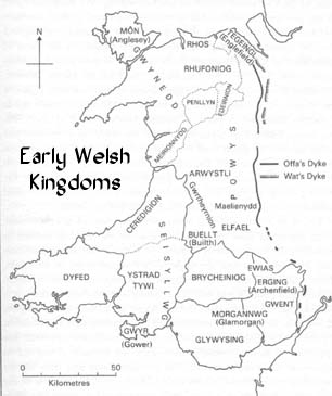 |
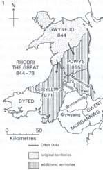
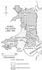
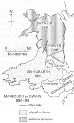
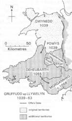
Mediæval Wales consisted of a host of petty kingdoms,
each overseen by a King or Prince; many of whom were really little more
than tribal chieftains. The larger and more influential of these
kingdoms were Dyfed and Gwent in the south, Powys in the midlands and Gwynedd
in the north. Gwynedd proved to be the most influential.
Wat's Dyke, built during the reign of Æthelbald
of Mercia (716 - 757) and Offa's Dyke, built during the reign of Offa of
Mercia (757 - 796) served to denote the Welsh frontier. |
The Welsh political system resembled
the English system in that a ruler presided over a clan, and clan members
vowed allegiance on the basis of the personal strength of the ruler.
However, according to Welsh law, on the death of a ruler, the kingdom was
divided among the heirs. This, along with a poor economy, lack of
town development and the absence of a feudal system inhibited royal expansion.
In spite of these obstacles, no fewer than four rulers did manage to unify
the separate Welsh kingdoms for short periods. Click on their name
for further details:
|
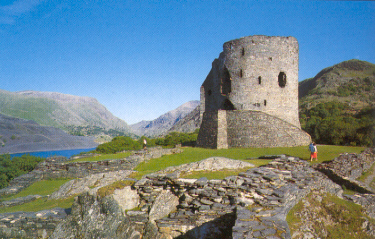
Dolbadarn Castle, Llanberis, Gwynedd
Stronghold of Llwelyn Fawr ap Iowerth (1173 - 1240)
Click to return to Gwynedd
and Wales
Please visit the Sewell
Genealogy Site Map for other pages in this series.